Australia spans an impressive landmass, stretching approximately 3,860 kilometres from its northernmost point at Cape York in Queensland to its southernmost accessible point at South East Cape in Tasmania. From east to west, it is almost 4,000 kilometres wide, extending from Cape Byron in New South Wales to Steep Point in Western Australia. These extremities define the vast geographic reach of the continent, with coordinates marking their exact locations; together, these points form a natural frame around a continent of staggering scale and diversity.
| Extremity | Destination | Latitude | Longitude |
|---|---|---|---|
| North | Cape York (Cape York Peninsula, Queensland) | 10° 41' 21" S | 142° 31' 50" E |
| East | Cape Byron (Byron Bay, New South Wales) | 28° 38' 15" S | 153° 38' 14" E |
| South (Mainland) | South Point (Wilsons Promontory, Victoria) | 39°; 08' 20" S | 146° 22' 26" E |
| South | South East Cape (Tasmania) | 43° 38' 40" S | 146° 49' 30" E |
| West | Steep Point (Shark Bay, Western Australia) | 26° 09' 5" S | 113° 09' 18" E |
| Highest | Mount Kosciuszko Summit (New South Wales) | 36° 27' 13" S | 148° 15' 29" E |
| Lowest | Kati Thanda-Lake Eyre (South Australia) | 28° 40' 5" S | 137° 31' 16" E |
Over the course of three unforgettable years, our family set out to visit all seven of Australia’s extreme points — each one more breathtaking, challenging, and memorable than the last. We began at the Tip of Cape York, the northernmost point of mainland Australia, reached only via remote red-dirt tracks and creek crossings that demand serious 4WD experience. From there, we journeyed east to Cape Byron, Australia’s first place to see the sunrise. Down south, our youngest—just 6 years old at the time — conquered the demanding walk to South Point in Wilsons Promontory, proving that age is no barrier to adventure!
Explore our itineraries hassle-free with these recommended services!
Car Rental
We stood on the windswept cliffs of South East Cape in Tasmania, peering into the endless Southern Ocean. We navigated remote roads to reach Steep Point, Western Australia’s furthest frontier, where sheer cliffs meet the Indian Ocean in spectacular form. We hiked to the summit of Mount Kosciuszko, Australia’s highest point, through high alpine trails dusted in summer wildflowers. We descended below sea level to stand on the vast salt flats of Kati Thanda–Lake Eyre, the continent’s lowest point. And to mark the heart of it all, we also made our way to the Lambert Centre of Australia — the geographical centre of the continent, tucked away in the red centre of the Northern Territory.
Some of these destinations can only be reached on foot; others demand confident 4WD skills and navigation through true wilderness. But the effort is more than worth it — because the journey to these extremes is just as powerful as the places themselves.
This post brings together every step, kilometre, and campfire along the way. It’s a guide, yes — but also a story of connection. To the land, to our family, and to the incredible landscapes that shape this country. If you’ve ever dreamed of going to the edge of the map — this is how you do it.
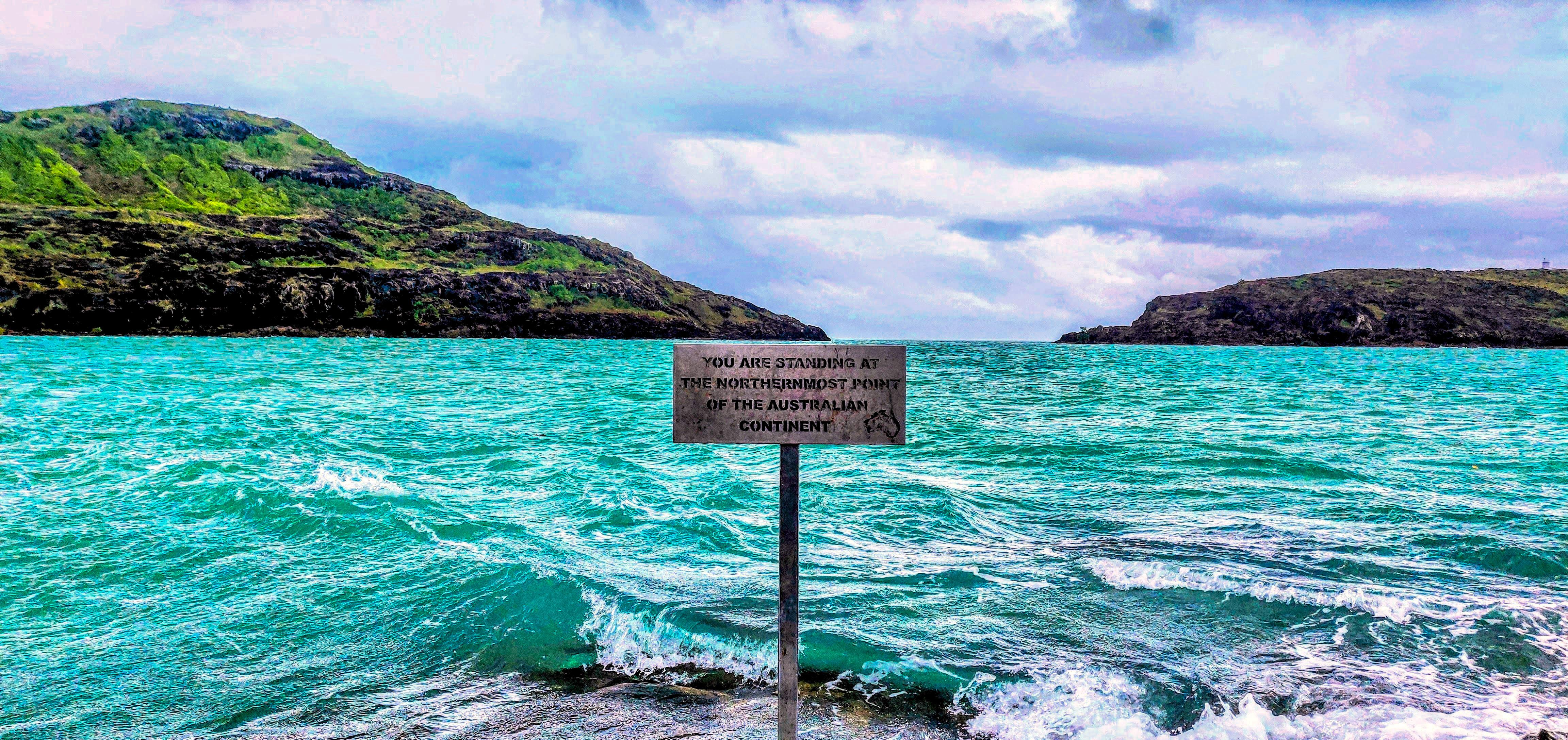
Northernmost Point: Cape York (Pajinka), Queensland
Known simply as “The Tip,” Cape York is the northernmost point of mainland Australia and lies in the far reaches of Queensland. The nearest town is Bamaga, approximately 40km away, and reaching Pajinka is an adventure on its own. Whether you embark on the rugged 1,000km 4WD track from Cairns or opt to fly into Bamaga and drive from there, this journey is not for the faint-hearted.
The final stretch involves navigating corrugated tracks and a short rocky walk before arriving at the windswept headland overlooking the Torres Strait. As you stand before the iconic sign reading “You are standing at the northernmost point of the Australian continent,” the sense of isolation, wonder, and triumph is undeniable.
📍Stats:
- State: Queensland
- Closest Town: Bamaga (approx. 40km)
- Accessible by: Multi-day 4WD or flight to Bamaga + short drive and walk
👉 You can find more about visiting The Tip in our itinerary post An Unforgettable Trip to the Tip (Cape York).
▶️ You can also watch our adventure on YouTube here.
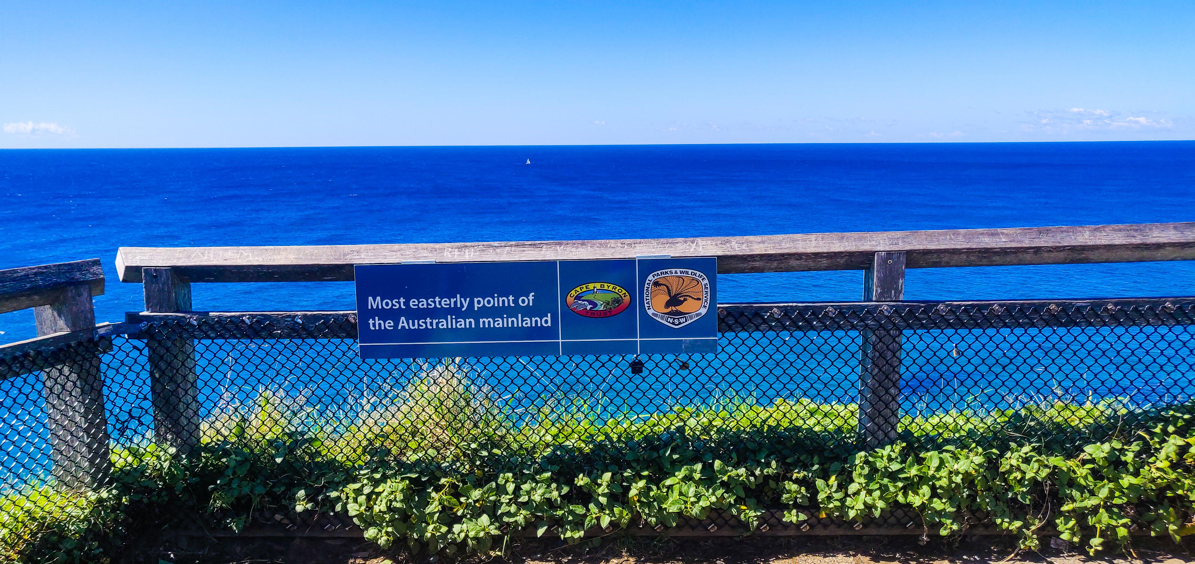
Easternmost Point: Cape Byron, New South Wales
Cape Byron sits above the turquoise expanse of the Pacific Ocean and is Australia’s easternmost point. Located just 3km from the vibrant town of Byron Bay, it is easily accessible via a scenic walking track that loops around lush coastal rainforest, cliffs, and the famous Cape Byron Lighthouse.
Start early to catch a magical sunrise — the first light to touch the Australian mainland. From June to November, this area is also a haven for whale watching. The 3.7km Cape Byron Walking Track provides both beauty and accessibility, making it perfect for all fitness levels.
📍Stats:
- State: New South Wales
- Closest Town: Byron Bay (approx. 3km)
- Accessible by: Grade-3 Walking track (approx. 15 minutes from Cape Byron Lighthouse)
- Trailhead: Cape Byron Lighthouse
👉 You can find more about visiting Cape Byron in our itinerary post Visiting the Most Easterly Point of the Australian Mainland.
▶️ You can also watch our adventure on YouTube here.
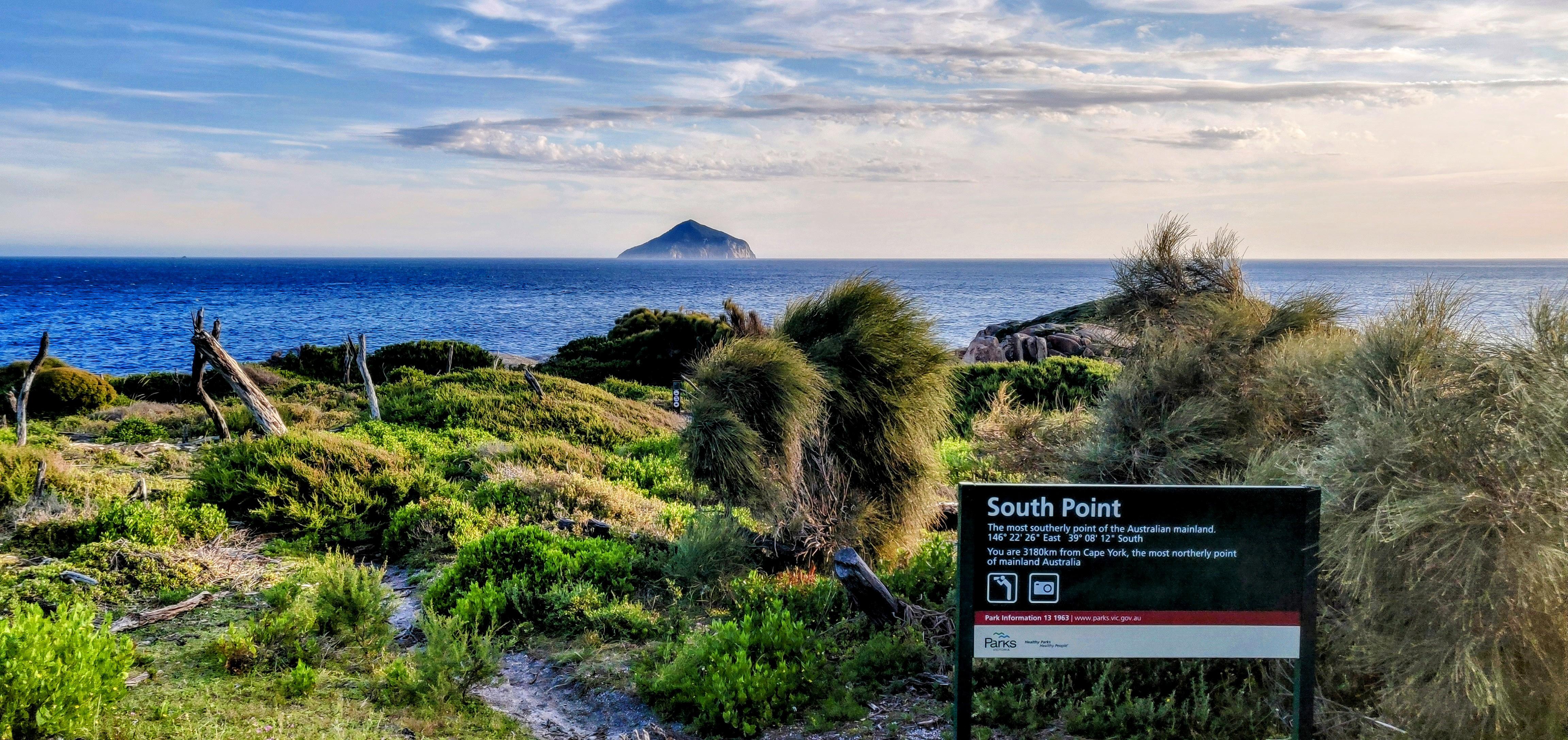
Southernmost Point (Mainland): South Point, Victoria
Tucked away in the rugged beauty of Wilsons Promontory National Park, South Point marks the southernmost tip of mainland Australia. Reaching this remote location requires a 32km return hike from Telegraph Saddle car park near Tidal River, usually completed over two days.
The trail winds through windswept heath, and coastal scrub, offering serenity and seclusion. The feeling of standing at the edge of the mainland with waves crashing into the rocky shores is unforgettable. This spot is extra special for us — it was conquered by our youngest adventurer at just 6 years old!
📍Stats:
- State: Victoria
- Closest Town: Yanakie (approx. 50km)
- Accessible by: Multi-day Grade-4 hike (32km return)
- Accumulated Elevation Gain: 932m
- Trailhead: Telegraph Saddle car park
👉 You can find more about visiting South Point in our itinerary post Visiting South Point: the southernmost point of the Australian Mainland.
▶️ You can also watch our adventure on YouTube here.
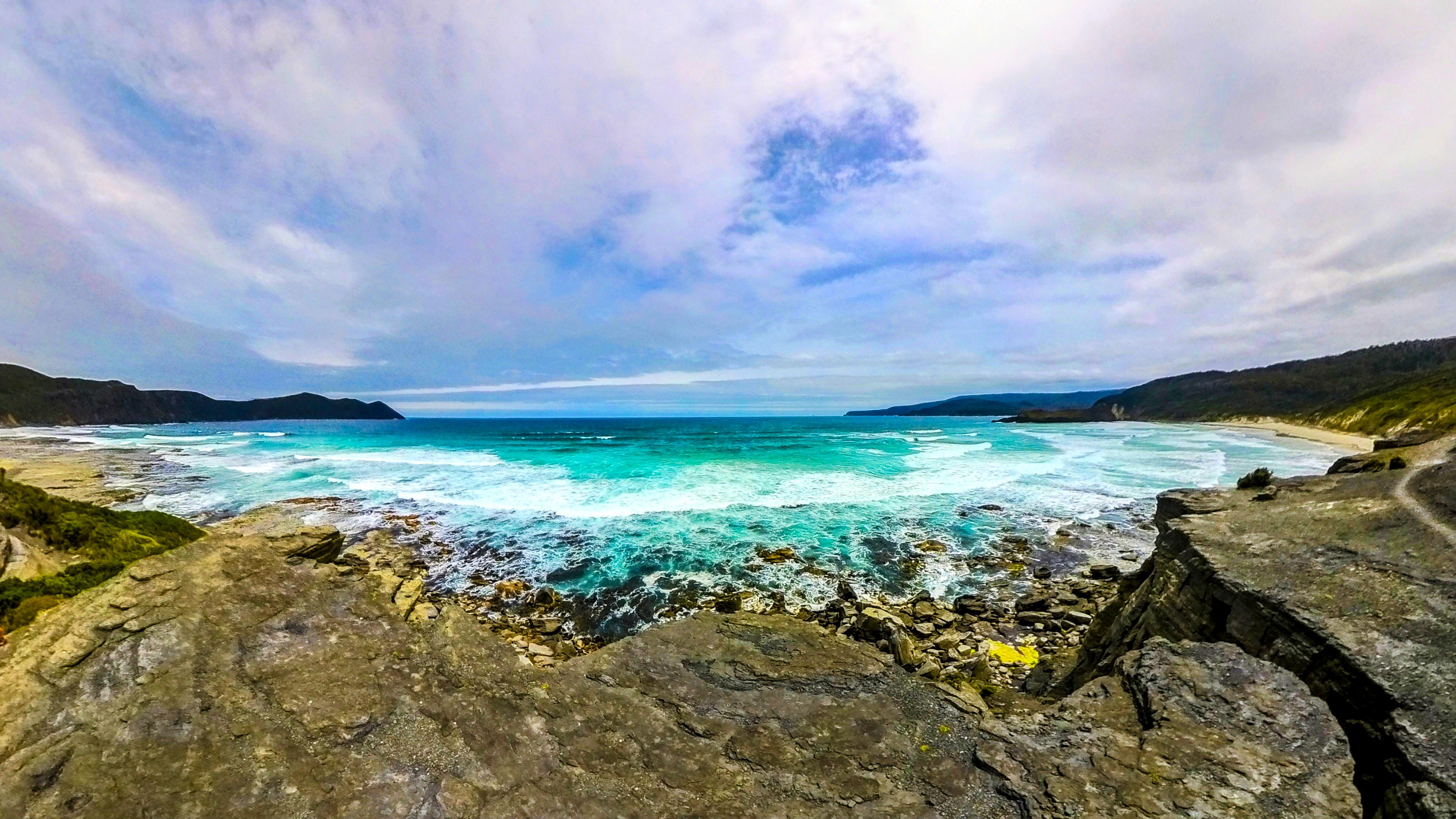
Southernmost Point (Continent): South East Cape, Tasmania
South East Cape, located within the pristine Southwest National Park in Tasmania, is the southernmost point of the Australian continent. While South East Cape itself is inaccessible, South Cape Bay becomes the southernmost publicly accessible point of the Australian continent. The nearest settlement is Cockle Creek — famously known as the southernmost road-accessible point in Australia, quite literally the end of the road!
From Cockle Creek, a 15km return trail leads you through eucalypt forests and buttongrass plains to the dramatic cliffs of South East Cape. This is where raw wilderness and coastal isolation converge.
📍Stats:
- State: Tasmania
- Closest Town: Cockle Creek (~2-hour drive from Hobart)
- Accessible by: Grade-3 hike (15km return)
- Duration: 4 - 6 hours
- Accumulated Elevation Gain: 225m
- Trailhead: Cockle Creek Campground
👉 You can find more about visiting South East Cape in our itinerary post Conquering the Edge at South East Cape, Australia's Southernmost Point.
▶️ You can also watch our adventure on YouTube here.
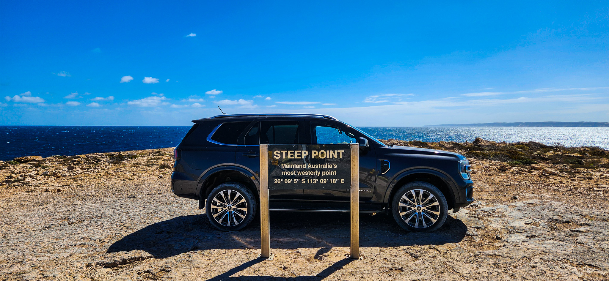
Westernmost Point: Steep Point, Western Australia
Located in Shark Bay World Heritage Area, Steep Point is the westernmost tip of mainland Australia—and it’s only for the truly adventurous. The closest town is Denham (about 200km away), and reaching the point involves traversing sand dunes, and heavily corrugated tracks via the Useless Loop Road.
This is a 4WD-only experience, involving tyre deflation and precise driving skills. Once at the edge, you’re rewarded with dramatic limestone cliffs, turquoise seas, and an overwhelming feeling of being at the end of the Earth. Few have made it here—and even fewer will forget it.
📍Stats:
- State: Western Australia
- Closest Town: Denham (approx. 200km)
- Accessible by: 4WD only (sand dunes, heavily corrugated track)
- Conditions: Remote; access can be closed after rain
👉 You can find more about visiting Steep Point in our itinerary post Steep Point: A 4WD Adventure to Mainland Australia’s Westernmost Tip.
▶️ You can also watch our adventure on YouTube here.
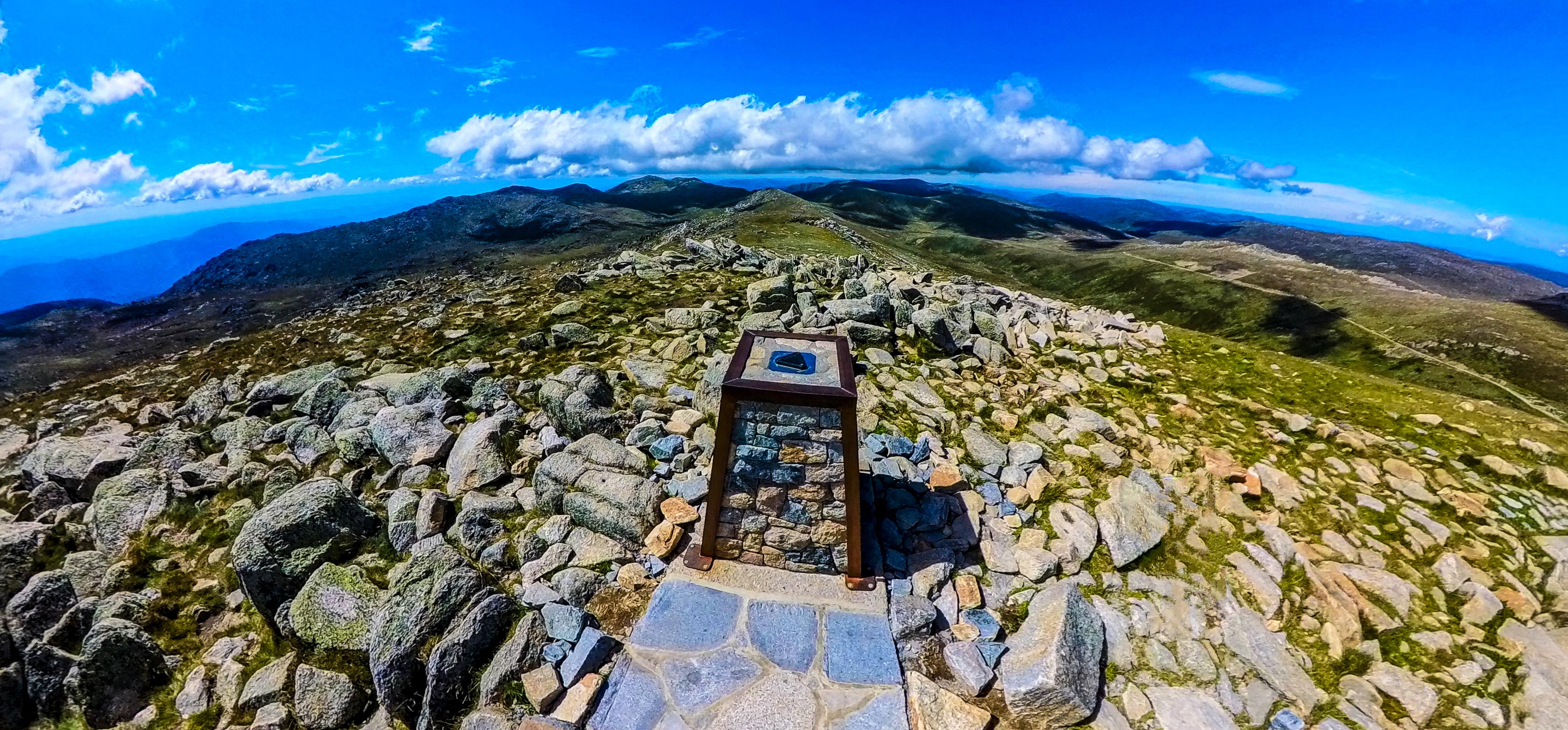
Highest Point: Mount Kosciuszko, New South Wales
Mount Kosciuszko, standing tall at 2,228 metres from sea level, is Australia’s highest peak and a must-do for hikers and families alike. Located within Kosciuszko National Park, it’s accessible via a scenic single-day summit walk from Thredbo (13km return).
The summit track from Thredbo features a chairlift to the alpine zone followed by a well-maintained trail with sweeping views, wildflowers, and a summit marker worth celebrating. Even in summer, temperatures can drop, so come prepared!
📍Stats:
- State: New South Wales
- Closest Town: Thredbo
- Accessible by: Grade-3 hike (13km return)
- Duration: 4 - 6 hours
- Accumulated Elevation Gain: 365m
- Trailhead: Kosciuszko Chairlift Station
👉 You can find more about summiting Mount Kosciuszko in our itinerary post Conquering the Highest Point of Australia: An Epic Journey to the Summit of Mt. Kosciuszko!.
▶️ You can also watch our adventure on YouTube here.
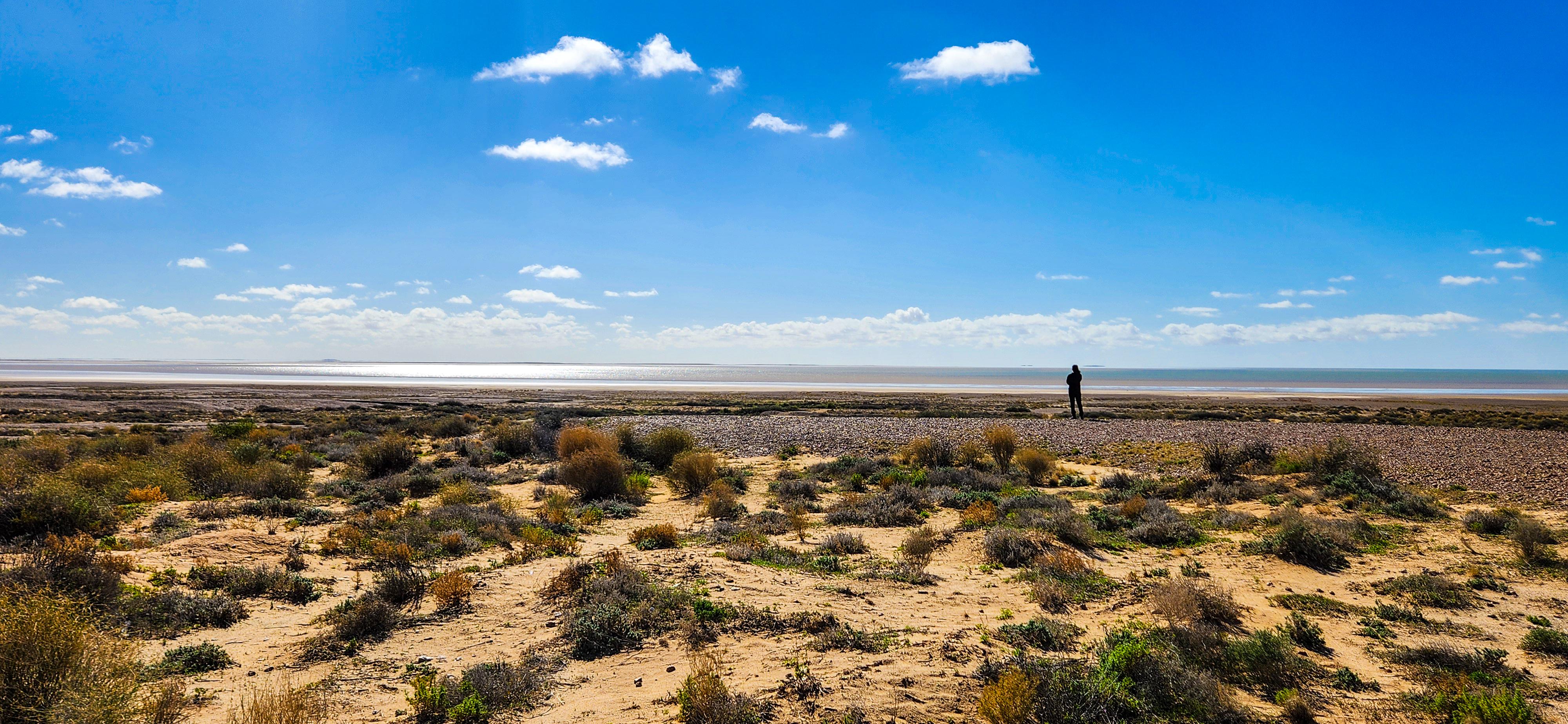
Lowest Point: Kati Thanda–Lake Eyre, South Australia
Kati Thanda–Lake Eyre is Australia’s lowest natural point at 15.2metres below sea level and the largest salt lake in the country. Located in the arid heart of South Australia, the closest town is Marree, about 90km away via the Oodnadatta Track.
When dry, the salt pans stretch to the horizon. But after rain, the lake transforms into a shimmering oasis, drawing birdlife and photographers alike. Getting here is no simple feat — the roads are remote, often corrugated, and conditions can change rapidly. Our journey after a recent deluge made for an especially challenging drive, but the reward was unlike any other.
📍Stats:
- State: South Australia
- Closest Town: Marree (approx. 90km)
- Accessible by: 4WD via Oodnadatta Track
- Conditions: Remote; access can be closed after rain
👉 You can find more about visiting Kati Thanda–Lake Eyre in our itinerary post Kati Thanda–Lake Eyre: A Journey to Australia’s Lowest Point.
▶️ You can also watch our adventure on YouTube here.
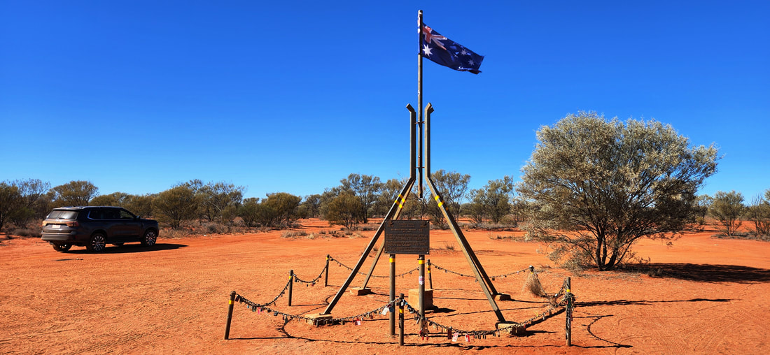
Geographical Centre: Lambert Centre of Australia, Northern Territory
Hidden in the red sands of the Northern Territory, the Lambert Centre of Australia marks the geographic centre of mainland Australia. It lies approximately 140 km east of Kulgera, which itself is about 20 km from the Northern Territory–South Australian border. To get there, you’ll take the corrugated unsealed Finke Road towards Finke and then follow a sandy, unsealed track winding through bushland. A high-clearance 4WD is essential for tackling the sand, washouts and ruts.
The reward is truly unique — a tall flagpole standing proudly in the desert, an exact replica of the one atop Parliament House in Canberra, commemorating this central point of the nation. There’s also a plaque and a visitor book you can sign to mark your visit. You’ll likely have the place to yourself, and in that silence, you’ll feel the vastness of Australia enveloping you from all sides. This isn't just a point on a map — it's the beating heart of the country!
📍Stats:
- State: Northern Territory
- Closest Town: Kulgera (approx. 140km)
- Accessible by: 4WD only (rough, sandy tracks with minimal signage)
- Conditions: Remote; limited phone reception; avoid during or after rain
👉 You can find more about visiting the Lambert Centre in our itinerary post Lambert Centre of Australia: Visiting the Geographic Heart of the Country.
▶️ You can also watch our adventure on YouTube here.
Visiting the extreme points of Australia isn’t just a geographic achievement — it’s a deeply personal journey. Each location pushes you out of your comfort zone: through remote roads, tough hikes, or moments of total solitude. For our family, the reward wasn’t just in the destinations. It was in the shared experience, the challenges we overcame, and the memories we created together. From 4WD adventures to summit walks and oceanfront sunrises, every point brought its own magic. If you're ready to explore Australia in its boldest, wildest form — this is your invitation to begin. Start at the edges; find the heart!
Love our itinerary? Excited to visit the Extreme Points of Australia? Book your accommodation via Booking.com below at cheaper prices!
This post may contain affiliate links. This means that, at no additional cost to you, we may earn a small commission if you make a purchase through the links provided. These commissions help support our website and allow us to continue sharing our travel experiences. Thank you for your support.
This itinerary is based on our personal experiences and recommendations. All information is provided for general guidance only and may change due to circumstances beyond our control. Travellers are encouraged to independently verify details and make choices according to their own preferences and safety considerations. We do not accept responsibility for any loss, injury, or inconvenience sustained by anyone using our itineraries.